Aruba to Colombia
Many of you ask how It went, so here is a quick recap.
The leg Aruba to Colombia is pretty tricky to sail compared to the rest of the Caribbean and high on the “World dangerous sailing spots Top100” list. There are a few points of consideration if you are not familiar with those waters. You may use it or not, your choice. We did it only once. But we spent some time researching and talking to locals, and this is what we learned and experienced.
- Never leave Aruba if the winds are 25+kn ( check the gusts!)
- Stay away from the Venezuelan coast as far as you can, due to recent piracy attacks.
- Make sure you don’t rely on just wind forecast. It is necessary to take into account gusts, rain, and thunderstorms activity.
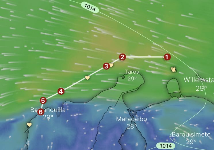
- Stay about 20miles off Gallinas (2) and Cabo de la Vela (3). If Cabo de la Vela is rough (waves or counter current) – make it 50nm – no joke, boats are lost there regularly.
- Gallinas is the most northern point of Colombia. Sea bottom there forms the narrow trench between the eastern and western Caribbean Sea. That means an increased speed of the current, which reaches 2kn+, speeds up the swell and shortens the period. Even with the easy winds, you feel that your boat is acting a bit weird.
- The coast between Gallinas and Cabo de la Vela produces a big night breeze. (Day breeze as well, but it goes towards the land, and it is not felt that much offshore). It can reach the wind force up to 40kn, and it is visible on the weather charts only if you have a close look at the coastal points. The breeze starts between 10pm till about 1am. It is better to avoid that time.
- The coast between Cabo de la Vela (3) and Santa Marta (4) is high mountains. The highest peak, Pico de Columbus 5775m, is located only 42km inland. This is the highest coastal mountain in the world. This mountain range – Sierra Nevada de Santa Marta – stops all small systems from the East and creates big cumulonimbus that seems to stick to the land. If there is a tropical wave on the way, thunderstorms will travel along across the Caribbean Sea.
- If you go further south to Puerto Velero (6) or Cartagena (past Barranquilla), make sure that you cross river Magdalena (5) during the day. There is 4-5s swell coming from the northeast (in no-wind conditions reaching over 2m), and there is a counter-current from the south. When the current intensifies, the swell period shortens. River spits a lot of debris (Magdalena is the biggest river in Colombia). Locals talk about dead cows and trees. We saw massive tree logs and floating islands of branches, grass, and leaves, we didn’t see any cows ;).
- Thunderstorms are not a joke here, activity lowers from December to March.
- Punta de la Vela has an infamous reputation for killing sailors and breaking boats, so take it seriously.
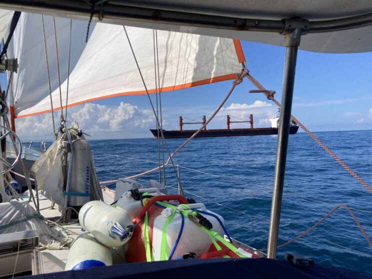
- By Barranquilla and Santa Marta, the traffic is bigger than everywhere in the Caribbean. Ships are mostly visible on the AIS and pretty responsive.
- Locals sail close to the coast, but still, they mind the timing at points 2,3, and 5.
We had an interesting passage: wind-wise super easy, thunderstorms- super stressful. Due to big currents and thunderstorms, we had to slow down, speed up, and zigzag to avoid the extensive lightning activity (even if the weather forecast returned a very low cape factor value, the thunderstorms were basically everywhere). As for forecasting, the ECMWF model was better for the wind and rain (and was better everywhere in the Caribbean), for thunderstorms – GFS.
Next time we will write about the cost of entrance and fee for the agency. We’ve heard so far that bay-hopping doesn’t really make much sense because you have to pay for the Zarape and agent every time you move outside the district. We are leaving White Dog in the marina and starting the backpacking trip soon.
Yo-ho!
White Dog Crew – chapter Colombia

Waypoints used for the passage:


Really useful post thank you!
thank you!
Thank you for your info.
You are welcome
Hi, thanks for this very useful information. We are in Curucau and I’d appreciate it if you could send us the we co-ordinates.
Thank you, we will send you email today.
Thanks for summarizing the key points about this passage.
Hi – nice website and good info on central America sailing.
Thanks!
Excelent post!! Thanks a lot!!!
Take into consideration:
Punta de la vela (3) is called “Cabo de la vela”, there’s a “punta de la vela” north of Riohacha and it could be mistaken for that one!
Thanks!I will correct it